


Map Distance Meter
Map Distance Meter의 설명
This application allows you to measure the length of a path on the map.
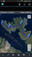
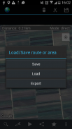
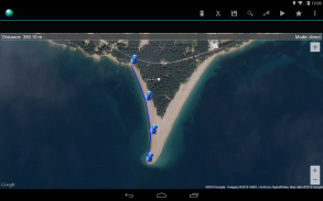
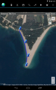
Create the path by tapping the map. Different modes of path creating are available: direct, driving, walking and bicycling. Direct mode draws straight lines between points. Driving, walking and bicycling modes are able to find and follow roads between points. Driving mode finds routes using the roads network. Walking mode uses pedestrian paths and sidewalks (where available). Bicycle mode uses bicycle tracks and preferred streets (this is currently available only in US). Distance between first and last point is shown on the top of the screen. It is possible to get your current location. It is also possible to save and load routes.
Internet access is required. Choose between metric and imperial distance units.
For feedback and support send email tompeharda@gmail.comPlease report bugs if found. Improvement suggestions are welcomed.
Use this application only for informational purposes. Do not use it for making important decisions.이 응용 프로그램은지도에 경로의 길이를 측정 할 수 있습니다.
지도를 눌러 경로를 만듭니다. 경로 만들기의 다른 모드를 사용할 수 있습니다 직접, 운전, 도보 및 자전거. 직접 모드는 점 사이의 직선을 그립니다. , 운전 걷기 및 자전거 모드는 점 사이의 도로를 찾아 수행 할 수 있습니다. 모드 운전은 도로 네트워크를 사용하여 경로를 찾습니다. 모드를 걷는 것은 보행자 경로 및 보도를 (가능)를 사용합니다. 자전거 모드는 자전거 트랙을 선호 거리 (이것은 단지 미국에서 현재 사용할 수있는)를 사용합니다. 처음과 마지막 지점 사이의 거리가 화면 상단에 표시됩니다. 그것은 당신의 현재 위치를 얻을 수 있습니다. 이 경로를 저장하고로드 할 수있다.
인터넷 액세스가 필요합니다. 미터법과 제국의 거리 단위 사이에 선택합니다.
조언 및 지원을 위해mpeharda@gmail.com에게 이메일을 보내
발견하면 버그를보고하십시오. 개선 제안을 환영합니다.
정보를 제공 할 목적으로이 응용 프로그램을 사용합니다. 중요한 의사 결정에 사용하지 마십시오.
Map Distance Meter - APK 정보
APK 버전: 2.7패키지: com.peha.mapdistancemeterMap Distance Meter의 최신 버전
다른 버전들


동일 카테고리의 앱


